The big forecast snowstorm for most of west Texas was largely an epic bust for the South Plains. While some areas saw at most 2″ accumulated, precipitation mode had a hard time changing over, and staying, as snow, courtesy of a warmer layer around 3000 feet up and surface temps that wanted to hang around just above freezing. After driving around parts of the South Plains for about 4 hours, we saw little snow. I can tell you what snow did fall was very wet, sticking very efficiently to road signs and power poles. If it had been able to switch over to all snow, I have no doubt we would have been in the high end totals expectations.
Areas to the west and southwest faired better for snowfall totals. The Carlsbad, NM area saw some decent totals, some 6-8″ last I heard, and even lost power to part of the city due to the wet snows. Van Horn down in southwest Texas also manages about a foot of snow, being in close proximity to the Davis Mountains.
North Texas is now currently enjoying our winter storm with widespread reports of 2″+ accumulated.
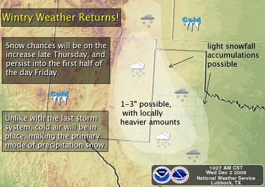
Attention now turns to snow Thursday and Friday. Unlike this past event, cold temps will not be a problem with time, due to a strong cold front that plowed through during the wee hours this morning. It’s currently sunny, and still windy and very chilly outside, with temps around 40F. So any precip that does fall, should do so as all snow.
Right now the National Weather Service thinks the best snowfall potential is south and west of a line from Tulia to Floydada to Jayton, which takes in over 3/4 of the Texas South Plains, parts of the Panhandle and the eastern New Mexico plains.
As usual, if this plays out, I’ll be out in it!
Tags: snow, winter weather