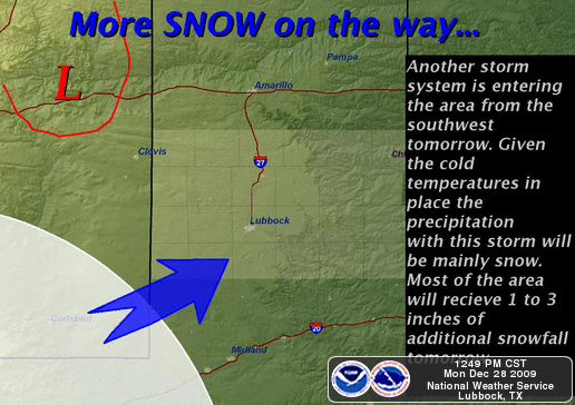
With snow still on the ground across the Southern Plains, Mother Nature is about to hit us with round two less than a week from the epic Christmas Blizzard we had less than a week ago!
Yet another storm system over Northern Mexico is getting it’s act together and has it’s sites set firmly on the Southern Plains. The eastern half of New Mexico and West Texas will be the first to take the hit, although this time it doesn’t look to be anything like the system a few days ago.
Snowfall totals should be quiet a bit less overall, but there could be some 4-6″ amounts to the northwest of Lubbock and in to the Texas Panhandle. 3″ or less should be more common elsewhere. Winter Weather Advisories have already been issued across the area for nearly all day on Tuesday the 29th. By late in the day, travel should become impacted as roads become packed with snow across the area. The system will then move on off into Oklahoma and Kansas.
Again, this doesn’t look to be anything like what we experienced a few days ago, but given we haven’t really warmed up much since that event, we are in for more COLD, that’s for sure!
I’m expecting to be streaming the snowstorm live on the LIVE ChaseCam at the very least on and off during the day from my house and possibly getting out mobile as things get more interesting later in the day.
There also doesn’t really appear to be any severe weather threat associated with this system, unlike the last one that produced tornadoes in East Texas!
You can get the latest on delays and closings at KCBD.com
The latest road conditions can be found on the TXDOT website or by calling 1-800-452-9292
For New Mexico Road Conditions or call 1-800-432-4269
Leave a Reply