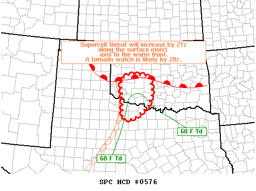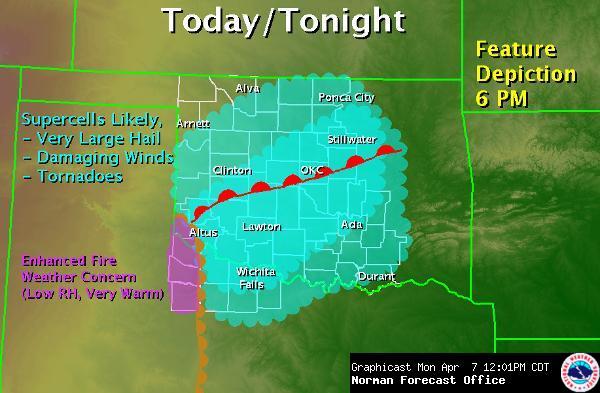
Things are shaping up today for a great day for supercell storms in western Oklahoma. The only real question today is, “How much moisture will be in place by initiation time?” All the other parameters look to be great for rapid supercell development late this afternoon. A warm front is moving across the Red River northward in to Oklahoma, with a dryline to the west and the areas south and east of that will be prime for severe weather. The intersection of these two by mid afternoon will ultimately determine the chase target for today. Wind profiles are nice throughout the layers of the atmosphere, with great directional shear. A few more knots in the speeds wouldn’t hurt, but it’s more than adequate.
Moisture… IF we can get low/mid 60s dewpoints up here in time, we could see a couple of significant tornadoes, particularly on any storms near that warm front, as winds will have a more easterly component in the low levels to aid in tornadogenesis. Very large hail will also be in the offering today, could be a real windshield smasher! Tennis balls or bigger possible!
I am running solo today. Drove up last night late and stayed the night in Lawton. Should be a good launching spot for any chase targets this afternoon. Once I get ready to hit the road I’ll put the LIVE ChaseCAM up and post an update here as to what the plan is.
If your reading this and you live in western OK, it would be prudent to keep a close ear/eye on whatever source you normally use for severe weather info. Tornado potential will actually increase on any storms already going after dark as the low level jet increases speed. I expect a long night. There will be briefings all day on the National Weather Service page.
Just as a side note, the last time I drove to a target area and stayed the night in a Motel 6 the night before, my motel was blown away by a tornado the next day…. nah, couldn’t happen twice… could it?