Summer finally truly arrived this week in west Texas.
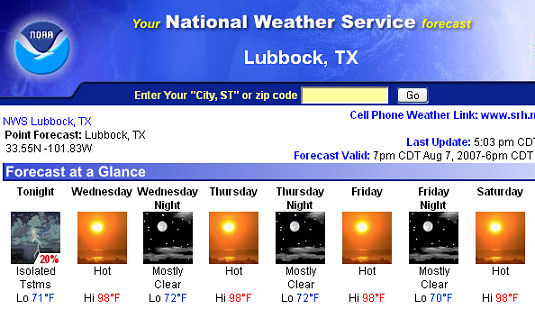
After an unusually cool summer here in west Texas, we are finally going to have some days near or above 100 degrees. For those of you reading in other parts of the country (or world) especially from up north, that might seem extreme, but it’s actually pretty common to have quite a few days in the summer hit 100 degrees or above here, most often in July and August. So far we have been seeing more temps in the mid and upper 80s rather than the mid and upper 90s.
We have not only been on the wetter side this summer, but also on the cooler side. I for one have much enjoyed this summer, as things have been rather pleasant and unusually green across the area, and even the dry land cotton is looking outstanding. The more intense rainfall we were having earlier throughout the spring and early summer has mostly tapered off, aside from a few renegade afternoon thundershowers. Even so, dewpoints have remained unusually high for this part of the country this late in the summer. Even today as I write this, dewpoints in the mid 60s are common across the area, making it feel much more like north and east Texas than typically dry west Texas, where common dewpoints in the afternoon this time of year are often well under 40F. For those less familiar, dew point is a measure of the moisture present in the atmosphere, in this case just above ground level.
Official high temperatures at the Lubbock International Airport averaged 5.4 degrees lower than normal in May, 3.3 degrees lower in June and 2.6 degrees lower in July. The highest official temperature so far this year at the airport has been 98 degrees, although that stands to be matched or broken this week. We have also passed our climatological peak for high temperatures, so the chances for days at or above 100F are slipping away.
It was over a decade and half ago in 1991 that Lubbock made it through the year without officially breaking 100 degrees. Will we have another record year this year? This week will tell! If this comes to pass, it will only be the 5th time since records have been kept that this has ever happened.
It’s interesting to note that across the area, other observation stations are reporting a similar trend of cooler and wetter than normal conditions. Looking at the nearby Childress, TX records also shows out of 31 days, only 2 days in the normal range for temps.
All of this bodes will of course for an early and more typical fall season. I’ll go ahead and go on record and say we will see an earlier than typical first frost and freeze date this year, along with a healthy, wet winter. As the clash of the titans of Summer and Winter to once again take their Fall battlegrounds, this could potentially set up a few good severe weather episodes for the southern plains, giving us a decent 2nd season. It certainly seems the moisture isn’t in any hurry to stop hanging out in the plains.
Of course of great interest to this writer, and I suspect most readers, is now will this play for next Spring and an active storm chase season. I am not a fan of long range forecasts whatsoever, other than just general trends and pattern recognitions, but you live out on the plains long enough, you do get a “gut feeling” for these things, that prove themselves more often than not. I know, not very scientific, but it works for me. 🙂 Of course neither I, nor anyone else knows what is in store of us next Spring.
We came into 2007 after an extremely crappy year for chasing in 2006, that rivaled 1988. Spring 2008 will be following a more wet and cooler year on the plains, and a pretty active year for chasing. I think the southern plains will once again be active, perhaps even more later into the season than 2007 proved to be (it was great early but then shut off down south early as well). 2008 may very well see a more “normal” severe weather season for the southern part of the plains, perhaps even with Oklahoma regaining some of it’s “Tornado Capitol of the World” status back.
Mother nature always finds a way to balance things out.