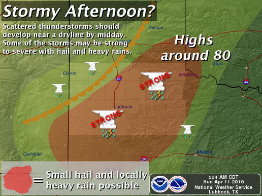
Usually be this time in April, we have had a severe weather episode or two across West Texas. So far this year that has been pretty much non-existent so far this spring, but that looks like it will change today.
Getting moisture back in west Texas at the same time as upper dynamics that are favorable for severe weather has been difficult to achieve. That, combined with a stout warm layer above the surface, known as the “cap”, which can suppress thunderstorm development. It almost seems as though our typical climatological weather patterns are running about 30 days behind schedule. Something I think we can attribute to the strong El Nino that brought us so many winter events.
While we can expect some low end severe weather across parts of west Texas today, it should be confined to low end severe hail and possibly a high wind event or two. Tornado potential is extremely low due to the weak wind fields throughout all layers of the atmosphere. However, there should be enough instability, and that aforementioned cap is weak today, that this should allow for quite a few multi-cell storms to develop. The instability could be enough to allow strong enough updrafts for the hail formation.
The good news is a fair part of the area today could see some meaningful rainfall! I’m thinking of areas along and south of a line from Cochran to Childress county. Multicell storms during the day should form into an MCS late this evening/tonight that should propagate south/southeast into the Permain Basin and Concho Valley.
For my storm chasing purposes, I’m mostly hopefully for some good lightning photo ops tonight!
Not much showing up on the long term weather models for any large scale severe weather events ANYWHERE in the plains in the next week or so. Some smaller scale processes could contribute to an event or two here and there, but those can’t be resolved on long term models.


