Something often talked about by storm chasers. It usually signifies the death of spring and the main storm chasing “season” for us. But what is it?
Well, quite simply it’s just an area, or “ridge” of high pressure that dominates a large portion of the continental U.S. during the summer. Most often it begins to set up mid-June or so, and lasts through until fall. You can see the death ridge on the 500mb charts, on the daily soundings and especially on the forecast models as it persists throughout the model period. Here is an example I grabbed today:
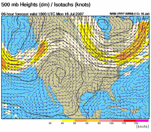
You can clearly see ridge or hill like feature on the map. What this effective does is shift the active weather patterns to the north in to Canada and the Great Lakes region and leaves the plains often under a hot and dry regime.
High pressure areas are not generally conducive to severe weather, thus the bulk of chasable storms on the plains ends once this ridge sets up.
This year, the ridge set up a little further west initially, which allowed the flow at 500mb to come from the NW out into parts of the plains, and coupled with abundant moisture created all the flooding conditions you have been hearing about. This has also been a contributor to the hot and dry conditions, and thus the wildfires, in the west.
Looking at the models today, it seems the ridge is firmly moving out on to the plains which should spell out relatively tranquil and dry weather for most of the central part of the country.
The Summer Death Ridge doesn’t spell the complete end of stormy weather. Depending on moisture conditions, parts of the plains, especially just east of the Rocky Mountains, can see daily low-end thunderstorms, what some chasers call “popcorn” storms. There are often short lived, pulse type storms that are slow moving and can be efficient rain producers. If the low level atmosphere is dry enough, they can produce damaging downbursts as well.
Of course all of this is out the window should a significant hurricane head toward the central gulf coast.
But, for some chasers, just seeing a cool storm is sufficient and several will no doubt find some interesting opportunities during the summer months for some good photography and chasing. In the summer, good chasing is where you make it.
However, until a sufficiently aggressive system comes in and starts to break down the ridge, this will be a pattern for some time. Enjoy the summer!
