On the heels of our Sunday system that was a chasing letdown, we have a really nasty system just now coming in to the southwester US that is going to bring a potentially nasty weather day to the central and southern plains. The Storm Prediction Center already has this area outlooked for a moderate risk for severe weather, with all modes of severe, included possible strong, long tracked tornadoes! Given the forecast setup, I would not be at all surprised to see a portion of that area upgraded to a HIGH RISK at some point tomorrow. This would be especially true if more heating, and the resulting increased instability were realized. Right now there is some question about how much instability will be available, due to early morning convection and cloudcover. That said, the overall setup is so strong it will compensate for that to some degree. I wouldn’t want to live in Oklahoma tomorrow if we get more heating that expected!
Quick rundown of the forecast setup. A tropical airmass is in place in central Texas that is already starting to spread northward as the LLJ is increasing, and expect to be about 50 knots by tomorrow afternoon! This to be topped by 500mb winds approaching 100 knots out of the west! That is some fantastic wind shear, both speed and directional. Dewpoints in to Oklahoma may be as high as 70F by afternoon. Several other parameters really looking good as well.
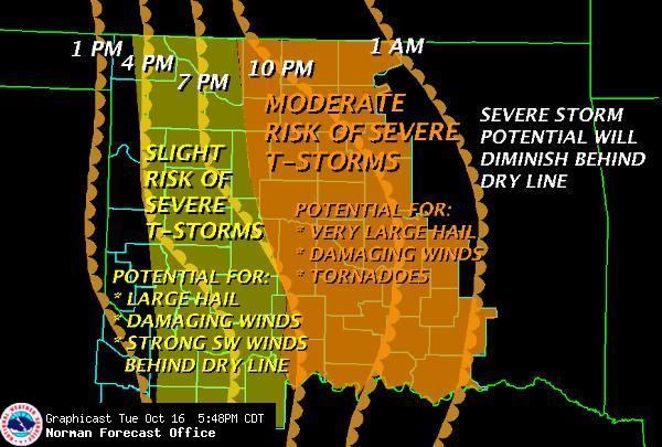
Two biggest concerns I had was the speed racer potential for storms tomorrow. Looks like from what I can tell, the fastest forecast storm motions were about 40mph. Not great for chasing, but doable. Looking at Norman’s forecast above, seems the dryline isn’t going to race through as fast as originally thought either. This bodes well.
The other negative was the potential overnight/early morning convection and stratus from the increased moisture. I will be looking for a good clearing area ahead of the dryline for a target tomorrow. That aside, it will be hard to go wrong any clear spot along the dryline in OK.
All in all, I think it could be a sad day from some folks on the plains, as we may be hearing of multiple damage reports, and we have at least 3 major metro areas under the gun as well, including Oklahoma City.
On another note, we are expecting severe weather in my neck of the woods late tonight. I may have to go out and report for the TV station. I am kind of hoping it doesn’t pan out so I can get a good rest and get on the road early in the morning.